Water’s Rising
Wednesday, May 25, 2011
The land where I grew up was once part of what was then called the Crow Indian Reservation in Montana. One early treaty declared that the land between the Yellowstone and Missouri Rivers in Montana would belong to the people of the tribe. Later the tribe was moved to the area south and east of the Yellowstone. Still later the reservation was cut down a few more times to the area surrounding the Big Horn Valley. The name of the tribe, like the Sioux, came from a French mis-translation of what they were called by another tribe. In the case of the Crow, it is a name given them by the Hidatsa, who called them the “children of the large-beaked birds.” The birds probably weren’t crows, but rather a forked-tailed bird such as the blue jay or magpie. They call themselves Apsalooke (sometimes spelled Apsaalooke). That name means “many lodges.” When we were growing up, we mispronounced their name and said Absarokee.
At one time the tribe had three or four distinct independent groups. The Mountain Crow (Awaxaawaxammilaxpaake) lived in the Boulder, Stillwater and Rock Creek valleys where they hunted deer and elk in the winter. In the summer, they moved out into the plains and hunted buffalo. The River Crow (Binneessiippeele) pitched their lodges alongside the Yellowstone River and sometimes along its tributaries. Sometimes they were called “Black Lodges” (Ashshipite). The “Home Away From The Center” band (Ammitaalasshe) were much more mobile than the others and ranged an area that now includes parts of Montana, Wyoming, Colorado, Nebraska and the Dakotas. They were known for their skill at stealing horses, and often had running skirmishes with the Lakota people. There also may have been a fourth group that eventually merged with the Kiowa.
The land that the Apsaalooke now occupy is the fifth-largest reservation in the United States, covering 2.3 million acres, mostly in Big Horn and Yellowstone counties. It extends from Billings to Hardin to the border with the Northern Cheyenne Reservation. It includes the Pryor Mountains. The major river in the reservation is the Big Horn, which is usually a gentle river. A large dam has created a reservoir that is good fishing and the tribe generates some income from tribal fishing licenses which are required of all fishers on certain sections of the river and reservoir.
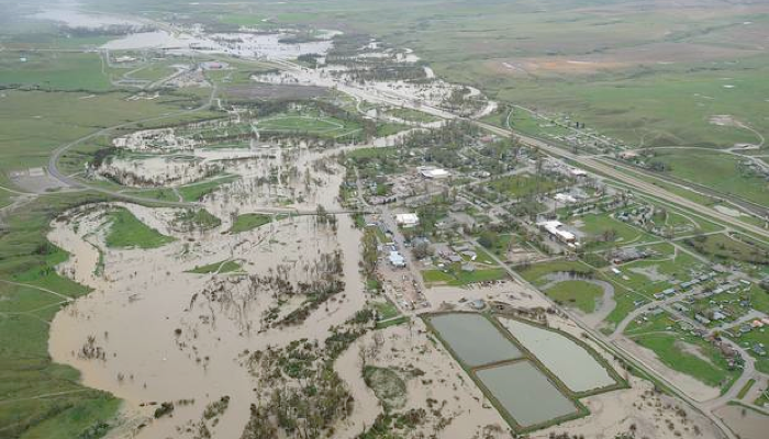
The river has ceased to have identifiable banks this spring as persistent rains add to unusually high snowmelt from the mountains. Two people have already died, both swept away while trying to move machinery away from the swelling Big Horn river. The ground is saturated with water from the rains and there is mud everywhere. There is extensive flooding across eastern Montana, with warnings issued for 35 counties. Another week of rain is being forecast. Access to Lodge Grass is only by boat for the present, creating a worry about a lack of food and water. The town’s water supply has been contaminated and is not safe to drink. There is a fear of Hepatitis A with the water treatment plants compromised by floodwaters.
Interstate 90 is closed from Hardin to the Wyoming Line. Highway 212 is closed to through traffic at Broadus with no word about when it will reopen. If we were to be heading home today, it would add about 75 miles to our trip to get around the flooded roads. Such an inconvenience is nothing compared to the struggles of the people living in the area to get supplies and protect their homes.
It is hard for us to imagine the conditions in Southeastern Montana as we rest in a campground alongside the Columbia River in Mosier, Oregon. We are in Oregon to visit Susan’s sister and conduct a little family business. We will return to Olympia tomorrow for a few more days before heading home this weekend.
The weather in the Pacific Northwest has been delightful, with sunny days and highs in the seventies. The weather forecasters, however, say that the water that is being dumped on Montana and the Dakotas is the result of Pacific weather systems that have stalled over those states. And there is more rain heading for the Pacific Northwest. Rain is forecast to begin today and continue through at least Tuesday of next week. We expect the rain to follow us most of the way home.
More rain is just what some of those places do not need, especially Lodge Grass and Crow Agency. The sewer systems in both towns has been overrun by flood waters.
I don’t know how many times in my life I have visited the Little Big Horn battle site or drive across the reservation when it was so hot and dry that any rain would be welcome. My mental image of the entire region is of dry hillsides with a few scrub pine trees and the trickle that sometimes cannot even be called much of a river of the Big Horn flowing through it. The reservation is different today and will be soggy for weeks to come.
The Apsaalooke have been through a lot in the past 150 years. The 6,800 or so people who live on the reservation mostly do not live in towns, but in isolated pockets of houses spread out across the land. It is hard to tell exactly how many homes have been or will be flooded. The people are used to taking care of each other and doing what needs to be done in order to survive. Survival is something they do well.
Crow Fair begins on August 19 this year. That is nearly three months away. There will be a pow wow, parades, rodeos, horse races, arts shows and more. The reservation will fill with people. But right now, it is hard to imagine what August will be like. The fair grounds are filled with water. The roads are under the river. Homes are filled with mud.
And the water’s rising. Still rising.
Copyright © 2011 by Ted Huffman. I wrote this. If you want to copy it, please ask for permission. thuffman53@mac.com. If you want to share it with a friend, please direct your friend to my web site.